My house is a whole 10 feet above sea level…a virtual mountain!
![]()
4 Likes
Their prices are different based on the quantity purchased - if you register for an account as a dealer then you will be shown all pricing info
2 Likes
Hi Deirdre,
I wanted to let you know that this bug with the label positioning and a few related display issues with the label font have been fixed now.
There is a also a new feature allowing custom markers to be added alongside custom labels so please feel free to try and generate your map now and let me know if it works correctly now.
Thanks again for the feedback
3 Likes
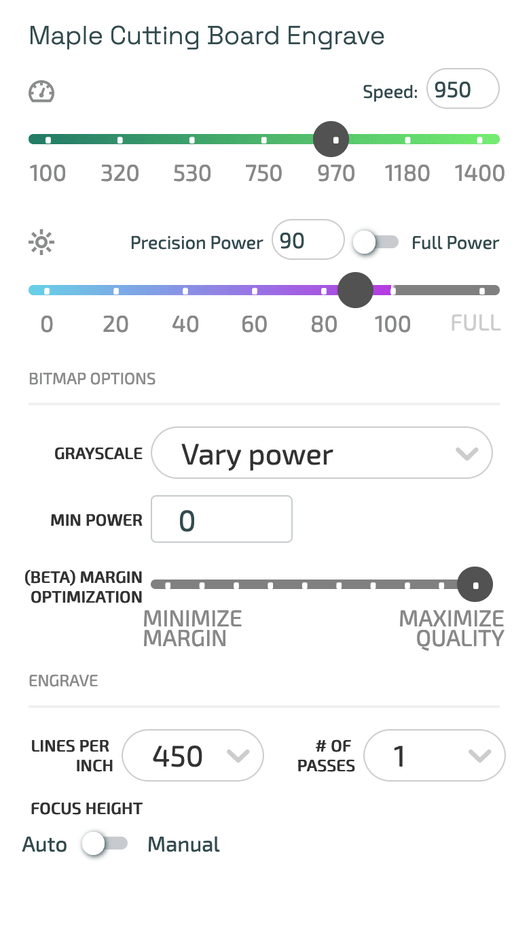
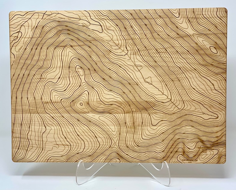
I realized I did not give any guidance yet on how best to get a great looking engraving of one of our maps using your Glowforge. The most important thing is to use the “Vary Power” setting under your materials control panel
These are the settings that work best for us when engraving into maple cutting boards - please note its not necessary to use any masking either - a light sanding cleans up the design nicely afterwards.
3 Likes
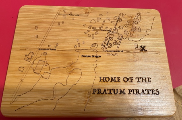
This is the ubiquitous ‘bamboo’…made for my grandsons’s school auction/fundraiser. I ran it for 2 passes at 1000 / 100 /340. With the extra time, it came out well. The lines are so tiny it needed the extra burning. Thank you again.
6 Likes
@Xabbess that looks great! Thanks for sharing
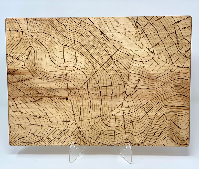
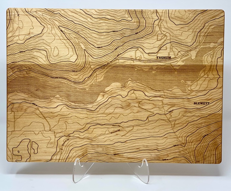
What I love about your example is that it shows how some locations that have little or no topography lines still give a good sense of place with a few roads and buildings and open up areas of the design to get creative with typography as you have done.
I find that the 450lpi is enough to get the finer details with one pass - a 15" x 11" maple board usually takes about 4hrs to do a highly detailed map with the settings posted above.
Take a look at https://cartocuts.com/showcase/ to see examples of how the maps look when engraved with those settings on cutting boards, cribbage boards, leather mouse pads and a few other products
2 Likes
Beautiful - I still had to turn the checkboxes off/back on to get the items to disappear on return to edit, but the label stayed exactly where I want it ![]() Now to figure out what to engrave it into!
Now to figure out what to engrave it into!
2 Likes
The two passes for this one took exactly 2 hours, so it might have paid off time-wise to raise the LPI. This is a very small board…only 6" x 8". I appreciate your input.
1 Like
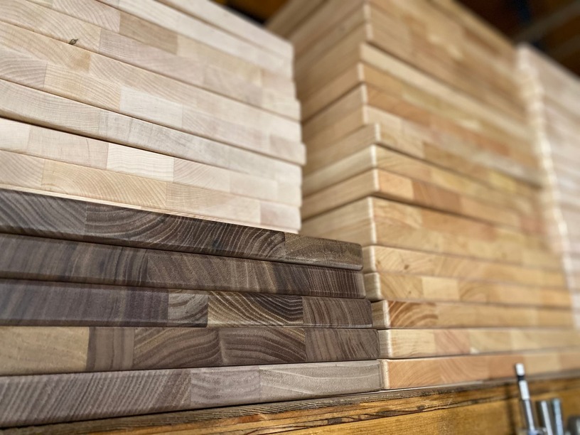
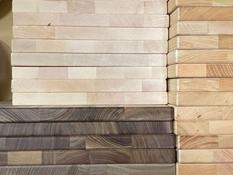
The boards arrived and look great, can’t wait to see what some maps look like on the cherry and walnut boards
9 Likes
Wow…looks like you are going to be really busy. Post a couple of pictures of a finished one.
2 Likes
These are a few examples from the last round of maple boards, I’ll post some of the cherry and walnut after the weekend.
9 Likes
Toggles for railways, street names off/on (doesnt seem like there is a way to turn of interstate/highway names), airports, parks,
If there was also a way to get water and parks to show up as different colors (blue/green) so they can be on different layers, this way cutting maps with 2 layers is easier.
Lastly SVG export
If these were all features on here I would be cruising through maps. I have a plan for an art wall of all the cities I’ve visited, but its just so cumbersome to go through the effort of converting stuff from google maps to SVG and layering, so I have just postponed doing this till someone much smarter than me can automate this.
If you’d like I can post an example map I made that would show what my intent is.
1 Like
Hi Stephen,
- Railways are for some reason proving to be difficult to get to show correctly - working on it still
- Street name labels should be able to be toggled on or off - I will look into why the highway names would not be included - I think it may be because they are being seen as icons instead
- At this stage - the app is only for raster engraving output and does not provide vector files to be able to cut from yet
- We have plans to try and implement a specific map style combined with auto trace to generate a svg export at some point in the future - not 100% this will work as planned but definitely going to give it a try
Please do post a map of what your intent is as it could help to inform how we build the feature in future.
3 Likes
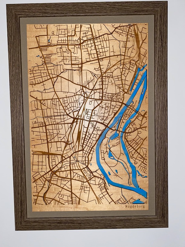
This is a map I made before, but it took way too long. Basically engraved roads with one setting, railroads with another (lighter engrave). The area that is blue is actually cut out and is a stained piece of wood behind it, that the main map is mounted to.
6 Likes
I tried out your app today. I made a quick map, hit the preview button, hit the “view high resolution” button, and it unexpectedly used up my free download credit without showing me or downloading the high resolution map. My “my maps” page is just blank. I tried 3 different browsers.
I also find it strange logging in using my first and last name instead of using my email. The first field on the signup form should probably be labeled “Username” instead of “Name”.
I then remade the map and purchased another download credit for $10. The purchase went through, I got the receipt from Stripe, but your app did not give me a credit. The app just stayed on the payment screen with the submit button greyed out. It says 0 downloads remaining even after logging out and back in.
The map editor itself is nice and the styles look good, but too much of your app was broken for me to use it today. Most of the links don’t work, including make map and support, unless I reload the page after clicking. Paying didn’t work, downloading didn’t work. I was going to use the map as part of a mother’s day gift, but I’ll have to come up with something new now.
2 Likes
Hi Dan,
Please don’t give up hope yet and thanks for the feedback. I will contact you directly to grant you your credits to try again - what I have noticed is happening and I am working on a fix for now is that if the map name is left empty - it is not saving correctly to the system and is making it hard to find the downloaded file. Do you know if you gave your map a name?
Opening a support ticket to make sure you get your mothers day map - sorry for the issues - things are still pretty new and has had a few teething issues this week
Thanks
Gregg
2 Likes
I don’t think I did the first time. I’ll give it another try tomorrow, thanks.
2 Likes
Hey Stephen, that map looks very cool - thanks for sharing - interesting to note that its a mix of cut and engrave
Thinking this feature idea through a bit, it would be cool to show each key layer in the interface and allow for a choice between cut or engrave - if engrave was selected it would be output as a png on its own layer and if cut was selected it would basically fill that layer (ie rivers or roads) with a solid color, run an autotrace operation and then be output as an svg - the download could then come in zip file with each layer as seperate pngs or svg files as well as one composite image.
Thanks for the feedback
Also thanks for the feedback about the username - I have updated the login and signup forms to say “username” instead of name, I agree that its simpler and clearer.
I also have fixed the issue with the My Maps page crapping out if you go to it and don’t have any maps yet - that was what was preventing anything being able to be clicked on once you visited that page
I am adding some additional validation to the make a map page to make sure that it has a valid title and then plan to also try and test the payment system with a few more cards to try and replicate the issue you encountered with not getting your credit granted immediately
Thanks again for the detailed feedback - it really helps
4 Likes
Please post back on here if anything gets updated towards this, its really exciting, the thought of this workflow being automated.
2 Likes