Hey all! Been lurking in the forums since I preordered, so this is my first post, but this resource is just too good not to share! NatGeo has released a tool that lets you find topological maps very easily. Seeing as these make great line art for all kinds of projects, it’s nice to have such an easy way to find em!
You rock!
4 Likes
Very Cool! 
3 Likes
Very nice! Thanks for sharing!
2 Likes
Excellent find, and welcome to the discussion, word of warning, though, once you start it’s hard to stop 
6 Likes
I think a better term is Topographic vs topological. And, welcome to the forum!
4 Likes
Thank you, bookmarked!
Glad something inspired you to post for the community, and that is a great source! 
2 Likes
Excellent. Thanks! Thanks for posting. Feel free to continue.
1 Like
Thanks for posting. It really helps the community
2 Likes
I love the these maps. I started thinking about how one would “vectorize” these maps to make cut paths for all the layers. I Googled around a little and found that the USGS will let you download topographical maps in a PDF format that I was able to import into Illustrator. The files are huge, the vectors use a lot of nodes and my laptop is chugging away right now. But this might be a great starting point.
See how I was able to select just the 500 ft elevation line!
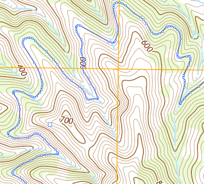
https://viewer.nationalmap.gov/basic/?basemap=b1&category=histtopo,ustopo&title=Map%20View
22 Likes
Nice work man, Thanks!
… that means you could Vector Score the whole map!
Now I am curious as to what you mean by “huge”?
Figured it out. The one I grabbed was from near Emerald Bay in Tahoe, where I used to go backpacking every year.
It was 30+ MB (pdf)
Opened in AI to find one layer full of clipping path groups, each of which in turn had a clipping group, which in turn held the actual paths.
I released the clipping groups, and turned off all the data other than the lines of elevation, and saved that as a new AI file: 3.4MB.
I don’t know what the GF servers would think of the big clunky version that I originally downloaded, but I imagine it would be a failure as a print for a bunch of reasons. Fonts are not embedded, and would need to be converted to outlines, and boolean operations might well be needed to mimic the white stroke on many text resources. Lakes, rivers, greenery, would all have to be dealt with in some way or another… separate layers?
The data is all there though, to be enjoyed! Awesome resource.
DicksLakeAreaTopoSimplified.pdf (3.1 MB)
8 Likes
Quick point here: the NatGeo site the @snookted posted was easier to navigate and find the pdf that I was looking for, but that did not give me vector data for most of the map. It was mainly small raster square sections. It did give me elevation hill-shading, and would probably be better for printing. It also split the map into printable sections; PDF is multi-paged, with a full map and then smaller bits.
The nationalmap.gov site that @GenieSoul posted is where I was able to download the ones with all vector data.
8 Likes
Cool. Thanks for sharing!
On a tangential path, does anyone know of a resource to take a vector based topographical maps like these and turn them into a 3D model for 3D printing?
I found this video helpful when I was playing with making 3D models from maps for CNC Carving. Can also apply to 3D Printing.

12 Likes
I have been digging around hoping to find this but somehow never made it to the right page before this. Thank you!
Oh, this is exactly the type of thing I’ve been looking for. I can’t wait to get my GF even more now. Thanks!
2 Likes
Excellent resource! Thanks!
1 Like