Anybody know anyone who would trace a bathymetric map of my lake for me or where I can purchase it already done? I would surely pay. I don’t have the software required to do so and I’m trying to figure out if I pay some for the file or buy the software.
What software do you have and use? You might be surprised at what some ingenuity and some free software can do.
Do a good search here for topographic as well as bathymetric as the techniques will be about the same.
1 Like
I have silhouette.
Inkscape is free, and arguably as capable as any paid software when it comes to use with the Glowforge.
It also includes a very good bitmap trace and edge detect function, which some paid software doesn’t do well.
GIMP is also free software and has a lot of capabilities with raster files that blend well with Inkscape even breaking out several images from one easily traced to vectors for cutting by Inkscape.
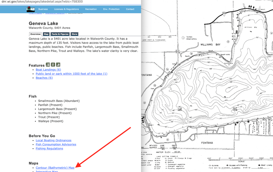
What lake? Sometimes the bathymetric data is “freely” available, but for Wisconsin, it is not. There are resources to help with this, but depends on where the lake is, from my experience.
Your state department of natural resources (different states, different names) may have lake maps on their website. The data to make your own using GIS software probably won’t be available, but a scanned pdf of a decades old paper map you can spend a few hours cleaning up may be available. That is what you get in Wisconsin.
Companies that make fish finders are crowd sourcing the data from their fish finders to make their own maps. By crowd sourcing, I mean getting the data from their users and charging a fee. If you know someone who is really into fishing they may be able to help.
4 Likes
Okay, if all you have at this time is the silhouette workspace download both GIMP and Inkscape and get be getting to know them. They are both free and both available for Mac and PC.
From there more specific help can be given.
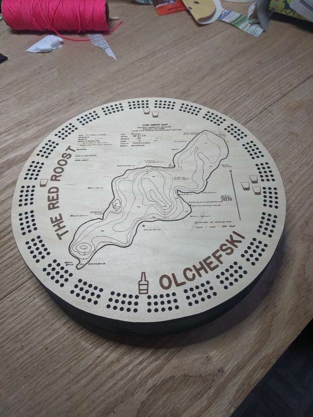
Geneva Lake. In Wisconsin of course.
Really not sure what else you could need…
(I found those, opened the file, took screenshots and edited in less than a minute…)
1 Like
Ok, I will download those. Thank you
2 Likes
Here is another resource:
https://webapp.navionics.com/?lang=en#boating@11&key=ktwbG|tf{O
Personally, I’d just trace the DNR map that @eflyguy posted. I have done that for a couple of other Wisconsin lakes, including Mendota, Menona, and Rest. Using the app listed above seems like there might be an export feature, but requires subscription, so no way to test.
When you say trace…is that hand tracing with Adobe Illustrator or using a trace feature that is within a software? I have only used Silhouette, which has a trace feature but all the depth lines do not trace solid because of the poor quality of the original map. I can try Inkscape or one of the other programs mentioned above if you think they have the capability. I have never tried them before.
You can use automated trace functions, then clean up the paths manually.
It takes significant time and patience to produce these - unless you happen to find a source with the information already in vector format.
You’ve never stated what your end goal is. The cribbage board I posted was engraved - no tracing required. I did have to clean up some stuff using a combination of GIMP and MS Paint. I suck at GIMP so what I did in it wasn’t terribly complicated.
If your end goal is to reverse engineer a bathymetric map in vector format, then you’ll need to trace the lines with something. If you just want to engrave it on something, cleaning up gray and off white pixels is a bit mind numbing, but easy.
This topic was automatically closed 32 days after the last reply. New replies are no longer allowed.