I saw this and instantly wanted to laser it! 
33 Likes
YES, YES, YES!!! Thank you for sharing! 
2 Likes
Wow. Totally.
5 Likes
I think inverting those b/w might give you a ‘more correct’ output as whites will be higher than blacks when doing a 3d engrave.
8 Likes
…WOW! This is amazing.
4 Likes
This is a typical cartographic technique of shadowing to the bottom (south) of the image versus the real shadow effect of a SUN that is to the south casting a shadow to the northern side of the slope --> you just don’t see it … it just doesn’t have the impact. Very nice, and I agree that this would be a fantastic laser rendering project.
7 Likes
The forum is on it today! Great find.
5 Likes
These are really cool! Reminds me of viewing the moon through a telescope; way more interesting around the quarters rather than a full moon, specifically because of the shadows near the Terminator line!
Edit: binoculars work too.
7 Likes
No South America, damn! 
3 Likes
It is amazing how much detail is in the shadows and the affects that they have on the images. Thanks for sharing.
2 Likes
You could certainly generate the images you want yourself. There’s all sorts of free (as in beer and as in speech) elevation and mapping data out there that you could pull into a 3d program of your choice to generate the lighting (you could even use a more realistic light / direction, if you wanted).
5 Likes
It appears that I live in the land of no shadows…
7 Likes
But only the Shadow knows … 
3 Likes
While I wait for my GlowForge, I have been generating combined STL, raster and vector files for all states in the US. The STL files will be used to carve 3D woods maps of each state using a CNC router, then the raster and vector files will be used to laser vector features like roads and rivers onto the 3D carved wood map using the GlowForge. It has been a fun project producing all the needed files and a challenge to have all the various data sets in registration.
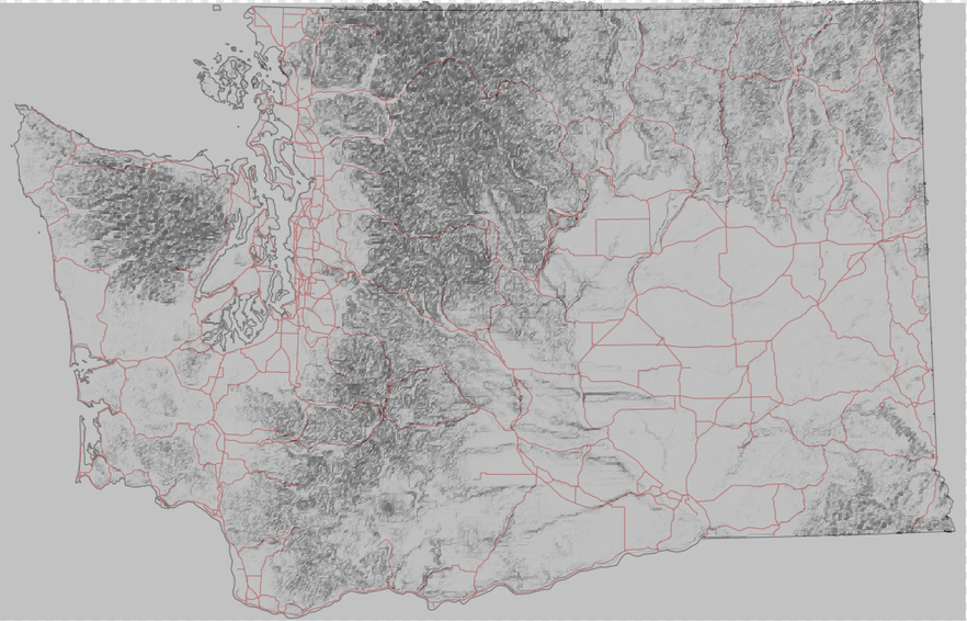
20 Likes
That’s a really neat project. Great idea.
2 Likes
@timtsuga This is a great idea to combine the CNC with the Laser. It will be cool to see how these turn out.
@joe Thanks for sharing this link. These are really cool! 
2 Likes
Ooooh… Super cool! Thanks for sharing
1 Like
That is a fantastic idea!
I can’t wait to see what this looks like when you get a laser.
I had been playing around with weird map projections that I could “seamlessly” engrave on wooden boxes. Data conversion from the various map formats is a huge pain!
2 Likes
@jkopel Here is a link to a site that has digital vector files of World maps in several projections, U.S Continental map file and all 50 states that may interest you, save you some time.
11 Likes
That is a great link!
Not quite what I needed though since I wanted to process “arbitrary” vector maps and make them project seamlessly on a cube (i.e. a box). There is code out there to do the projection changes but everything I found isl written for the existing weird GIS vector formats.
1 Like