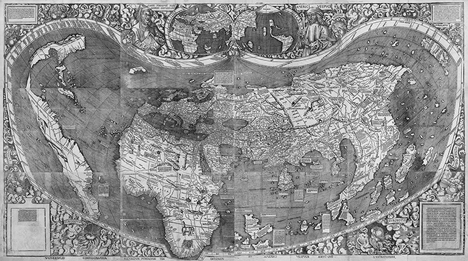
While awaiting my GF arrival, I’m working on art for my first big project: redrawing the Waldseemüller map for lasering onto multiple hardwood tiles. The map consists of 12 folios, which I plan to burn into roughly 11x8x1/8" wood sheets. Ideally I would like all the complex lines in the map to line up between each tile (I’ll print edge to edge) so it can be presented as a single map using a 4x3 grid of engraved folios.
My question about accuracy: if I generate an Illustrator file with each folio exactly matching edges with the next, how do you think each tile will fit together? (I’m drawing it all as one image, divided into the 12 folios.) The end result will be about 44" wide by 24" tall (12 tiles), and the contents are complex. Everything I’ve read seems to indicate the accuracy is excellent, but I haven’t found many people doing tiling (of course I might have missed it).
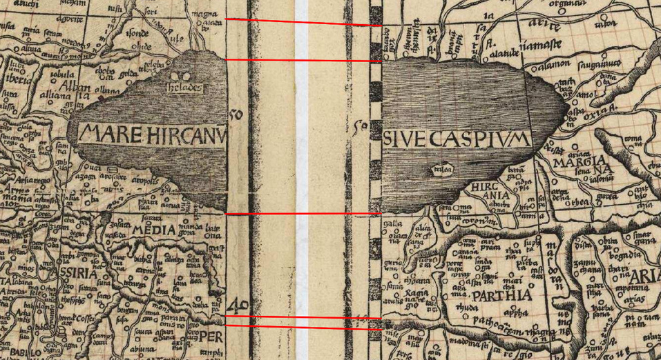
What a great project idea! I don’t think the GF will have any problems with tiling per se, but lining up the individual hand-engraved panels will be a challenge. Here’s a small section showing variations between feature alignment along two of the folios…
Yeah, the Library of Congress folios don’t line up very well… 15th-century printing technology wasn’t exactly pixel perfect which is part of why I’m redrawing the whole thing in Illustrator, without the folio edges. It’s a lot of work to redraw this, but it’ll be worth it, I think. I love the whole “old things rendered in a modern way” aesthetic.
keep in mind what your gutter will be when you install as well. you’ll want to account for that so the image breaks up logically, especially if the gutter will be larger.
Yep - I’ve actually taken the high-res image from Library of Congress and removed the gutters:
You can see where each folio is next to each other on the map, I want to keep those as the limits of each engraved folio but hopefully have the joins be less obvious than in this version.
Drawing the map: easy
Drawing the outside decorations: moderate
Deciphering the Latin names used: Frickin’ difficult
If you place your image inside a box so that the glowforge engraves the map and then cuts the box you are left with three issues I can think of:
The laser cuts down the center of the box, so there should be a white space border between your image and the box equal to half the width of the kerf at the surface of the material.
Unlike a perfectly balanced saw blade, the laser doesn’t leave you with a perfectly vertical edge. It should be slightly wider at the top than the middle, where the two pieces of wood will first meet when they butt up against each other. This is pretty slight on 1/8" material, but it will leave a line.
The cut operation doesn’t adjust power for corners, so there is a tiny amount of overburn at each corner. The only way around this I know of is to use the engrave operation to cut-through the material instead of the cut operation. This increases the time to make a tile, but these aren’t exactly going to be quick.
My suggestion is to take a small section of one of the tiles, place it inside a box and do some experiments with the material you are going to use. Once you have your kerf and engrave-cut versus cut decisions made, do one full size tile. It is possible the kerf doesn’t scale perfectly and it seems you are aiming for perfect.
If your plan is to pre-cut the wood and then place the image over it, well the accuracy will be better than 15th century printing technology. You can make a jig and if each of your twelve images are placed at the exact same coordinates on a 12x20-inch art board it will be accurate, but not as accurate as the first method because of the tolerances in the pre-cut wood and its fit in the jig.
No matter how you approach the tiles, I would recommend finding a helpful glowforge owner when you’re done with your first tile. The point being to see if the cloud software will successfully process your file (not to have someone actually print it.) While the software is continually improving, a particularly large file may just not print at this time. Sadly, you can’t tell just from file size - you have to try and see what happens. If this would turn out to be the case you would either need to make a map with more, smaller, tiles or wait for the software to catch up.
Excellent feedback and suggestions, thanks very much. I hadn’t thought of the laser angle, but I see where that could be an issue. I’ll likely do a lot of testing for it, and will definitely keep these things in mind.
 which is part of why I’m redrawing the whole thing in Illustrator, without the folio edges. It’s a lot of work to redraw this, but it’ll be worth it, I think. I love the whole “old things rendered in a modern way” aesthetic.