That is really beautiful! What a thoughtful and carefully thought out gift.
I have definitely followed and admire your mapmaking work @tclear01, but your layered maps are definitely beyond my current ability.
I did use these steps from
Laser Maps for Family
but used Illustrator
but mainly followed:
How To: Laser Cut & Engrave City Maps - Adobe Illustrator
Which was within my experience level.
The term “LifeMap” for this type of concept I came up on my own, although I later realized it is a very broad term that encompasses many other concepts as used on the internet.
The generous contributions of this community is a wealth of inspiration and support.
5 Likes
Really cool idea, Reynoso, thanks for posting.
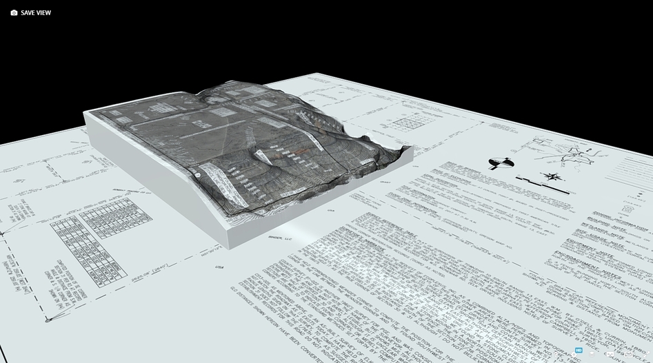
The whole reason I picked up a glowforge is to make 3D maps for work and I’m trying to chip away at developing a workflow as I have time. I’m really trying to avoid using a program like Illustrator to prep files for print because I do all of my work in CAD & GIS programs right now and I’d like to maintain the ability to align what I want using coordinates and maintain an accurate scale. We also work in state plane coordinate system (NAD83, not WGS84) and it looks like most of the built in mapping capabilities in vector programs are all using WGS84.
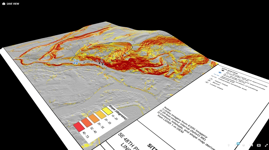
Right now I’m working on getting the raster imagery layers to engrave the way I want and still convey depth/elevation in 2D greyscale before I take another crack at making 3D maps. So far, using underlying terrain layers to apply a hill shade effect before applying a linear contrast adjustment seems to work well with the “HD Graphics” setting.
RONP2.pdf (2.8 MB)
I haven’t tried a full size print yet, but I’ll try a “prettier” site once I’m happy with the raster engraves. I was planning to use the contour lines to create cropping boundaries for the different elevation layers, and create a cut-out hole for a wooden dowel at the centroid of the upper-most polygon to use as a method of alignment.
These are the types of maps I’m hoping to produce on the glowforge. I prepped these ones for 3D print a year or two ago, but I’m not a fan of 3D prints for aesthetics when the maps contain any sort of text or symbology.
I’d love to be able to get these to come out clean & clear as well…
I still haven’t tried the 3D engrave yet because most of what I’m working with is 1/8", but do you have any recommendations on material to try on something like this? 3D Engrave Test.pdf (152.7 KB) Would it be possible to do a 3D engrave, apply some sort of primer or paint, and then do an HD photo engrave over the top to add text & linework to the 3D surface?
The above PDF is for this project site: ArcGIS Dashboards
P.S. - Shout out to “When Geeks Craft” on youtube for giving me the final motivation I needed to pick up a glowforge! The maps they made, along with what you all have posted here, has me pretty damn excited to figure out how to use this thing for making maps!
2 Likes
Congratulations on your first post @d_west! I am also interested in making 3D bathymetric maps cutting layers on the GF. I started with Illustrator and sketchup because I was familiar with them, but I really wan to learn CAD & GIS for future projects.
Thanks Reynoso.
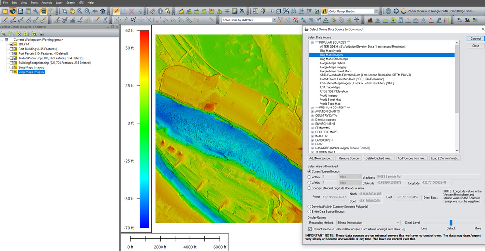
HUUUUGE recommendation to check out Global Mapper for what you’re asking. I use ArcMap/ArcPro and Global Mapper at work currently, and qGIS in the past. Global Mapper is hands-down the easiest to use, best value for the cost ($500), and can do nearly everything I need to do for work. I do photogrammetric mapping for an engineering/surveying company and Global Mapper handles just about everything that I throw at it.
As far as CAD goes, I don’t know of a low-cost option because we’re all pretty uniform over here. Everyone uses Civil3D or Carlson Autocad, but both are too damn expensive for home use IMO. I can do most of the map styling and vector layers (mainly terrain) that I want in Global Mapper, but it’s a lot easier for me to make custom linework in Autocad and import it into Global Mapper as a vector layer.
I was really excited to see that Glowforge recognizes vector layers in the PDF export from Global Mapper when you use the “Split data and elements into separate PDF layers” option.
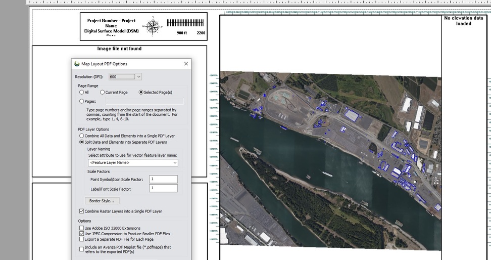
Here’s a screenshot of some of the out-of-the-box data sources available in global mapper. The terrain layer shown right now is a combined surface made from USGS LiDAR and public bathymetry data.
3 Likes
Such a wonderful gift!
This is beautiful!!! Such a unique gift! Love it!