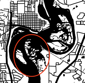
I have been looking for a solution to laser cutting a city map that happens to have a LOT of small islands/tidal areas in several surrounding rivers. I’d like to kind of combine them into larger sets so there will be less of them to place after the cut (sort of a 3d map with a water layer, then roads engraved so I’m cutting out all water). Am I missing a way to do this either with snazzy maps (or other map source) when creating the map or illustrator or inkscape after the fact? I did a test cut and wound up with like a zillion little land pieces many of which are teeny tiny.
Thanks for the quick response! I can delete them but what if I want to combine them into one land mass as all together they make up a significant feature but individually there are just too many to deal with?
I’d have to see what you’re working with to give more direct advice, but @eflyguy might be right, this might be a manual process. This begs the question of “how important is this to you?”
Again, if you post the map in question we might be able to offer more pointed advice. It’ll depend a lot on your source material and exactly what you’re trying to do.
You would be better off editing those areas as a bitmap, and using a paintbrush to fill in the gaps, then importing the finished areas to your vector program, and tracing the outlines to produce the required cut paths.
Another possibility is to find an alternate version of the area that has the islands like you want them and use that. Many mapping sites have automatic amounts of detail at various zoom levels.
Openstreetmap lets you export maps as svgs, people have had good success with them.