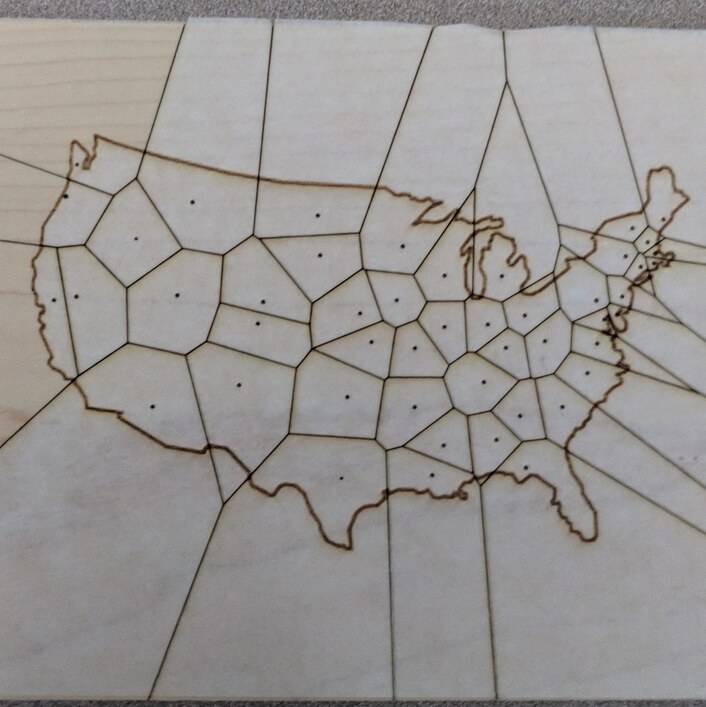
The dots are all state capitals. The new state borders are drawn so that, if you cross a border, you are now closer to the new states capital. So many interesting things happen!
41 Likes
Idaho just got weird!
3 Likes
Neat! 
(Texas got a bit decapped!) 
How about the fact that South Carolina and Florida now share a border… Georgia moves off the coast entirely.
Weird-er. 
3 Likes
Very cool! Interesting concept, but the Mississippi River might throw the borders out of whack.
1 Like
Think Delaware got bigger…
Rhode Island definitely did!
Hawaii now owns like half the Pacific ocean. 
2 Likes
Us Tn volunteers now seem to reside in a bullseye. 
1 Like
Almost looks like a potato. Karma.
1 Like
I’m in Memphis, so it looks like I’m actually in the Arkansas region. Makes sense, I guess, since it feels like West Tennessee is in a different part of the country than Middle or East Tennessee.
1 Like
haha Michigan pretty much unaffected (no one cares about the UP in reality har har.
1 Like
I assumed national borders would stay the same so Alaska and Hawaii would be unaffected
Lots of national border for Michigan.
These are the interesting things that I am not geographically skilled enough to see. Wonder what the biggest city to move states is, Nashville has to be near the top! Also I’ve been combing through to see if there is any state that LOSES a border neighbor. Plenty of states gain at least one.
I live in Indianapolis and it looks like Indiana would absorb Chicago
Not sure I know where I am. I see Lake Erie. But I can’t tell if PA is where NY should be or if PA is elsewhere. And did PA swallow up NJ?