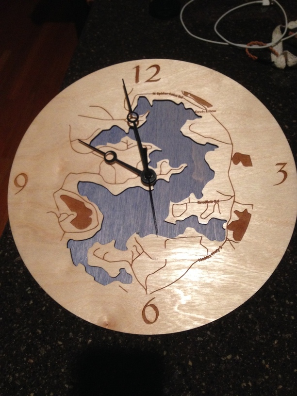
I made this like a topo map. Cut out the Lake and etched in the roads.
17 Likes
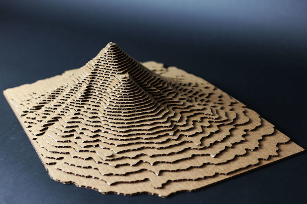
This arrived in my Instructables email today: http://www.instructables.com/id/Easy-3D-Topographical-Maps/?ALLSTEPS.
19 Likes
Bookmarked 
2 Likes
Bookmarked and experimented. Thanks!
2 Likes
I think I still have my map somewhere. If I can find it I’ll happily scan it for you. This was my favorite computer game of all time.
1 Like
Sticking this video here as a reality check for project planning: TLDW: It’s good to do some calculations in cost of time, materials, tools, design, and learning before setting out to make some money using a laser.

16 Likes
Ha! I came here specifically to pasty the same link that I found in my email today😁
2 Likes
And this is why I said the advent of the GF would not mean the topo map world would be saturated.
People are making money but there is more to it than getting a laser as he does a great job pointing out.
3 Likes
Maybe once I have the glowforge I’ll make a tutorial start to finish going from publicly available GIS data to 3D relief map. I might even be able to start soon with file prep.
5 Likes
One of the first big map projects I’d love to do is combine old, hand-drawn maps of cities with 3D topographical info of the region. I remember some studios using GIS back at school…as big of a pain as working in the software was, now I wish I’d actually attempted it!
I don’t think this site gives topographical data, but for pretty much anything else (including buildings and maybe even building heights if it’s a major enough region!) there is Cadmapper:
Downloadable files in a variety of formats are free up to 1 km squared! There’s no limit on how many freebies you download as well, so with a little planning you can grab a pretty big chunk of terrain in smaller clusters. You can even specify how much or how little of the available data you would like.
12 Likes
wow that sounds like it could be a lot of fun in VR too! Like a custom map explorer where you can travel around the world in any scale you want, add and change map layers, like oldschool map overlays, 3d overlays etc.
maybe even look down at mount everest, or take a seat in the pacific ocean and watch the waves roll over all the continents lol
3 Likes
It would!!! I really wish I had been born a little sooner so that I could have had the chance to work on game development for the first few Assassin’s Creed games…building and modeling Renaissance Rome, Florence, and Venice? That must have been so much fun!
2 Likes
its not too late! you know someone is going to attempt to remake the entire planet in 3d down to very small scale. not just that, but there are tons of games out there needing 3d modelers, especially someone with architecture chops!
1 Like
Alas in this simulation I can’t make myself 1000ft tall. If I could my scaled up lungs probably couldn’t handle the stress of breathing in this atmosphere. Even if I could I’d probably breathe up everyone’s air haha.
I can’t wait for a matrix/grid to happen to see what the equivalent of an ISO would be.
1 Like
Very true!! I could easily find myself being happy as a 3D modeler/architectural visualization person for my full-time job. I’ve thought about getting Unreal Engine to dabble in 3D walkthroughs of some of my school projects, but I just know I currently don’t have enough free time to devote to trying to learn it 
@jbv…whoa. 
Well that’s awesome. I don’t have enough time to fully investigate it right now though.
Here is the Link from the article incase anyone can’t find it easily enough.
3 Likes
I went to that site hoping to download the data, but I’m not sure what link from there will do the trick. What format is the data in?
Digital Elevation Model (DEM) files, both .kmz and .dem for import into GIS systems. KMZs can be imported into Google Earth.
Not directly usable by any off the normal tools we’ve discussed other than full-blown GIS. YMMV.
2 Likes