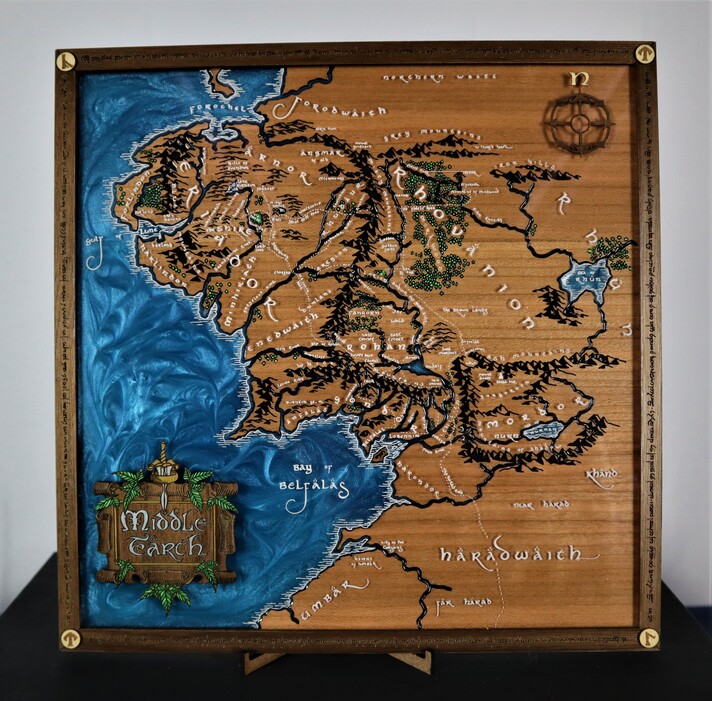
I make a lot of custom maps like this one. Every time I post a new map, I get more and more suggestions for future builds. One of my Instagram followers gave me a good one and I was surprised I hadn’t started it before. Middle Earth.
I was quite young when movies came out, but I do remember seeing them all in theaters. It seemed crazy to me that they could make such an exciting movie about basically walking. It wasn’t until I found a reference map that I realized how far they had to travel and how insanely detailed this map truly is.
From there I made the laser files but drawing out the sections for each layer.
We made a video showing how it was all put together but really I just want to show you guys how cool it turned out by sharing the image.
If you want this map or you want to make this map yourself, Check out the links in the YouTube video.
Have a great week, friends!
Nicole Christianson
When Geeks Craft
That’s so kind of you. I really do try to set up the intensity with each project. This one tested my ability with the syringe for the resin rivers as well as the veneer boarder being cut in pieces to save material. I’m glad you enjoyed it and i hope to keep providing more and more exciting projects!
I was headed off to college at the time the books first made a big splash in the US and for my “little” sister, then in high school, set the arc of her life’s work. The movies were the one case I wish I had worked on, as though CGI was becoming mature, so much of it was shot with cameras using largely real stuff of steel, wood, and leather and not even the movie prop fakery of much of the case before CGI.
I love the map but wonder if you have ever explored Bryce as V.5.5 is released as freeware and the more advanced versions are available, Particularly for maps you could engrave in 3D it could be very amazing. and 3d printing of everything else all the more so.
That’s super kind of you. Thank you. I feel like the Glowforge community really understands the work involved to make something like this so im glad they are so well received on here
I cannot say i have played much in the world of 3d modeling. I leave that to the other half of WHENGEEKSCRAFT, my husband, Thure. He handles everything that is electronics based or anything that required the 3d printer to do work. We are going to be working on a map of Utah for a gift and i have been trying to figure out how to 3D model that…would this software be a good option?
What you get is elevation data from the lowest point on the map to the highest rather than absolute numbers so getting all of Utah at once is a good thing but with only 255 elevations possible with that method and limited by the numbers of pixels across the map the bigger you go the poorer the resolution.
Bryce turns out nice grayscale elevation maps, but I did not use it for much 3d geometry, however, the Glowforge will cut from the elevation grayscale data,
For making stuff in actual 3d for a 3d printer I would use Blender that now also includes a slicer while the v5.5 Bryce was before 3d printers,

 I’m glad you like it!
 Thanks